Weekend warmup ahead of rainy week
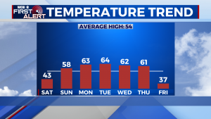
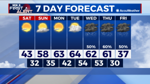
SATURDAY: Despite highs in the 40s, mostly clear skies will allow for continued warming throughout the region. Lows improve substantially into the low 30s after a night where the low was in the low 20s.
SUNDAY: Similar conditions to what was seen Saturday will occur on Sunday, although this time the afternoon high will be much more comfortable. Some more clouds return, but in general the sunshine remains, as we top out in the high 50s Sunday. Lows do not yield as big of an improvement this time around, only increasing into the mid 30s.
NEXT WEEK: The clear pattern continues through Monday before significant cloud coverage begins to move into the area Tuesday. Wednesday onward, the pattern stabilizes a bit into one of rain and overcast skies, further stalling any warming that had been occurring. Highs consistently in the 60s bring a delightful change in seasonal flavor, until another cold front moves through the region on Thursday.




Leave a Reply