Warmer temperatures ahead of overnight storms
COLUMBUS, Mississippi (WCBI) – Another warm and humid day in store for us ahead of storms developing tonight. Storms continue into our Friday morning with the chance of some of them being on the stronger side. We’ll have another round of showers early Saturday morning before drying out for the rest of this weekend.

TODAY – Starting off our Thursday with warm and muggy conditions, so there could be some patchy fog on the roads early this morning. We’re starting off our day with mostly clear conditions before clouds slowly start moving in from the WSW ahead of our next round of rain. We’re also expecting warmer temperatures today! More sunshine this morning and early afternoon allows for our temperatures to quickly warm up into the upper 80s!
TONIGHT – Cloudy conditions are in store through this evening before storms begin to make their way into NE Mississippi. Showers and storms will start to move into our western counties just before midnight tonight and continue to work their way across the region into the early hours of Friday morning. Overnight lows will be in the mid 60s tonight.

TOMORROW – Some of these overnight storms could be strong at times, so the SPC has NE Mississippi split between a level 1 and 2 risk for severe weather. The main threats with these storms will be heavy rain, gusty winds, and possibly some hail. Expect another warm and muggy day with highs in the low 80s. Scattered showers and storms continue throughout the rest of our Friday, so be sure to have the rain gear with you.
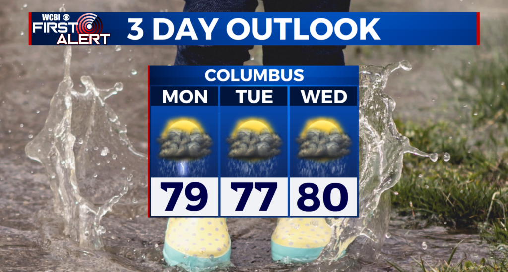
THIS WEEKEND – Looking ahead towards this weekend, we have some showers to start off our Saturday morning. We’ll see temperatures warming into the low 80s and clearing out for our Saturday evening. Pleasant conditions continue for our Sunday with mostly clear conditions and highs warming into the upper 80s!