Tuesday Tropical Update
Hurricane season has finally woken up! After all of the jokes, the tropics began ramping up production. There have been seven named storms and the peak of hurricane season has only just passed within the past couple of weeks. Out of those seven named, one has made its way into the major hurricane status by becoming a Category 3 hurricane (Hurricane Fiona). However, there are still about two months until the “official” end of hurricane season.
This time of year, the warm water temperatures of the tropics and the surrounding equally warm air are going to progress the formation of any systems even further. The warm ocean air will rise into the system, creating an area of low pressure underneath. The lower pressure will cause more air to move in and move in a lot quicker. Eventually creating a tropical disturbance.
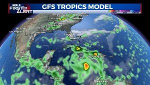
With that being said, there is a new tropical disturbance beginning to form. Invest 98L. The newest tropical wave is situated a few hundred miles East of the Windward Islands, the line of islands extending South towards Venezuela. It has continued to organize and strengthen over the past couple of days. Additional development is expected, as there are already moderate and strong thunderstorms taking place within the area surrounding this system.
This tropical wave is going to continue moving westward to west-northwestward at approximately 15-20 MPH across the eastern and central Caribbean Sea. The main threats to the Windward Islands are going to be heavy rainfall and gusty winds, possibly beginning as soon as Wednesday morning.
Invest 98L is expecting to form into a tropical depression within the next couple of days. Formation over the next 48 hours is high at 70%. Formation over 5 days is also high, now up to 90%. These formation chances are provided by the National Hurricane Center and the National Oceanic and Atmospheric Administration. Once developed, Invest 98L is going to be named Hermine. As far as placement goes, by day 5, this system will reach into the central Caribbean. Where is goes from there, it is still too far out to decide. As more information becomes available, the WCBI weather team will update.


