Thursday night’s storm explained
COLUMBUS, Mississippi (WCBI) – Hot, steamy weather led to a few intense storms across east Mississippi and west Alabama late Thursday afternoon, May 9th.
So, what happened? And why? Let’s take a closer look >>
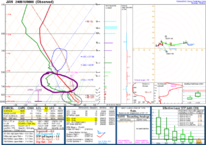
This is a sampling of the atmosphere in Jackson, MS shortly after 7 PM Thursday. While this isn’t exactly representative of the air over Columbus, it certainly gives us a good enough sample of what the atmosphere was doing. In short, there was extreme instability…especially for early May…and even though we didn’t have a lot of storms, the storms we did have became quite severe.
Blue circle: This is the hail growth region – the layer roughly between -12 to -18 deg C. There is a large amount of CAPE (convective available potential energy) in this layer, suggesting very strong updrafts and upward vertical velocities. In this environment, hail stones can grow and tumble in the updraft for quite some time. The yellow highlighted LI of -12 C suggests extreme instability.
Purple circle: This is indicating quite a bit of dry air between 10-15,000 feet. As the storm begins collapsing, this dry air can get “entrained”…making it cooler & heavier. This can make downdraft descend more quickly, increasing wind speeds along the way. This is, in part, what led to the estimated 50-70 mph wind gusts experienced across Columbus. The yellow highlighted DCAPE of 1300+ J/kg indicates an extreme amount of “potential” downdraft instability.
Black circle: This is showing fairly deep moisture and high enough temperatures to help “push” the air past the minimal cap around 750mb. Basically, if the air was drier at the surface and/or the temperature was lower, the air wouldn’t have been as explosive and the storms would’ve likely been much less intense. The yellow highlighted SBCAPE indicates extreme buoyancy/rapidly rising air potential at 5600+ J/kg.
Lastly, there was very little low-level shear. The 6 and 8km shear values certainly supported big storms, but with little shear near the surface, tornadogenesis was very unlikely to happen.
Meteorologist Ashleigh Bryant recaps more below >>


