Thursday night storm chance
COLUMBUS, Mississippi (WCBI) – Calm and comfortable ahead of our next storm chance Thursday. Stay weather aware.
WEDNESDAY NIGHT: A bit more comfortable tonight. Temperatures will not get as cold as last night. Overnight lows drop into the upper 40s to lower 50s.

THURSDAY: Wind will continue flowing in from the South, pulling moisture from the Gulf North. The first part of the day will stay dry, as additional clouds accumulate across the sky. A cold front moving in from the NW will initiate scattered storms across northern Mississippi from the late afternoon and into the evening. Strong to severe storms will be possible, with damaging winds and larger sized hail being the main threats. There is a Level 2 – Slight Risk across all of our coverage area. Rain will hopefully clear out by the earliest hours Friday morning.
FRIDAY: Clouds are likely to hang around throughout the day. There is continued potential for some late afternoon showers to pick back up. Temperatures will return to the middle 60s.
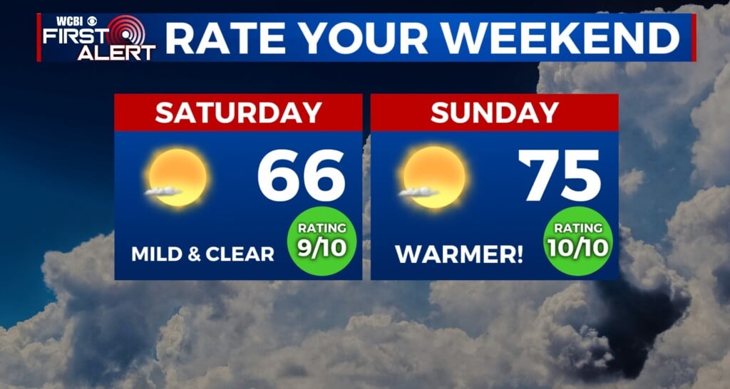
WEEKEND: What a nice weekend! Conditions are expected to be mostly clear and sunny. High temps will go from the middle 60s Saturday to the middle 70s Sunday!