Sunny, warmer Tuesday ahead of Wednesday front
COLUMBUS, Mississippi (WCBI) – Expect a warmer day Tuesday ahead of a strong front Wednesday afternoon. Spring begins Thursday with cooler air!
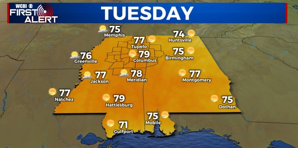
TUESDAY: Under a mostly sunny sky, temperatures will reach the mid to upper 70s area-wide. Southwest winds will gust up to 15-20 mph, and this combined with relatively low RH values, could create some slight fire weather concerns for some. Burn bans continue for Panola, Alcorn, and Itawamba counties.
TUESDAY NIGHT: Passing clouds with lows in the low 50s – warmer than previous nights!
WEDNESDAY: Ahead of a cold front, expect a mix of sun & clouds with highs in the 70s. Limited moisture return ahead of the front will limit heavy rain/storm potential, but strong forcing will still promote the risk of a few locally heavier storms in the afternoon/early evening. One or two storms could grow severe with gusty wind the primary concern, but the coverage and intensity should be relatively tame.

THU/FRI: Spring officially begins Thursday! Highs will struggle to get out of the 50s Thursday afternoon ahead of a potential FREEZE Thursday night. Friday looks fantastic w/plenty of sun.
WEEKEND: Quiet weather continues Saturday, but showers and storms return Sunday evening. There could be a severe weather risk, so stay tuned for more updates!