Storm chances continue through Wednesday ahead of Thursday PM front
COLUMBUS, Mississippi (WCBI) – A relatively active pattern sets up over the next 5-7 days with storm chances along with an occasional shot of drier air or two!
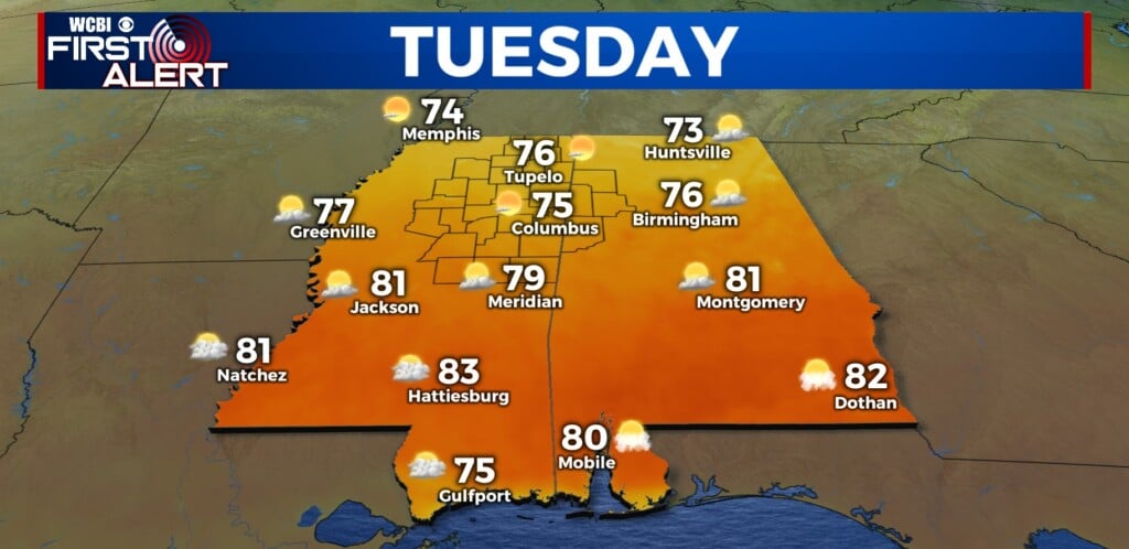
TUESDAY: Monday night’s storms are out, and we’ll see a mix of sun & clouds through the day before additional storms develop in from the west. Highs should stay in the 80s, but with dew points in the 70s, the heat index could briefly exceed 90 degrees in spots. Another complex of storms could roll in from the west, and a few instances of damaging wind gusts are possible with this feature this afternoon…likely after 3 PM.

TUESDAY NIGHT: On thunderstorm outflow from earlier storms, renewed & scattered showers and storms are possible overnight. Depending on how storms set up and if the train, some localized flooding issues could arise.
WEDNESDAY: One more round of scattered storms looks likely Wednesday afternoon before we get a brief upper-air pattern shift.
REST OF WEEK/WEEKEND: As the upper-air flow becomes more amplified, a front looks to push through Thursday afternoon. We’ll turn hotter into the lower 90s before it passes, but a brief reprieve in the humidity is expected Friday & Saturday. Things have trended toward another front Sunday, and we could see additional scattered storms.