Staying Warm & Unsettled
SUMMARY: A somewhat active northwest flow pattern in the upper levels of the atmosphere will keep elevated rain and storm chances going through the weekend. Several clusters of storms are possible each day during this time. A building ridge of high pressure early next week may push highs back up into the mid 90s.
THURSDAY NIGHT: Variably cloudy overall with just a slight chance of a shower or storm. Lows in the low to mid 70s with light and variable wind.
FRIDAY: Scattered showers and storms with the chance of precipitation at 50%. Any storm may produce locally heavy downpours, gusty breezes, and frequent lightning. Highs should top out in the upper 80s to around 90. The heat index may surpass 100° at times. Look for variable winds between 3-8 mph. Lows in the low to mid 70s Friday night.
SATURDAY: Additional showers and storms are likely with the chance of rain staying around 50%. Highs top out in the upper 80s to around 90. Lows Saturday night will remain in the 70s.
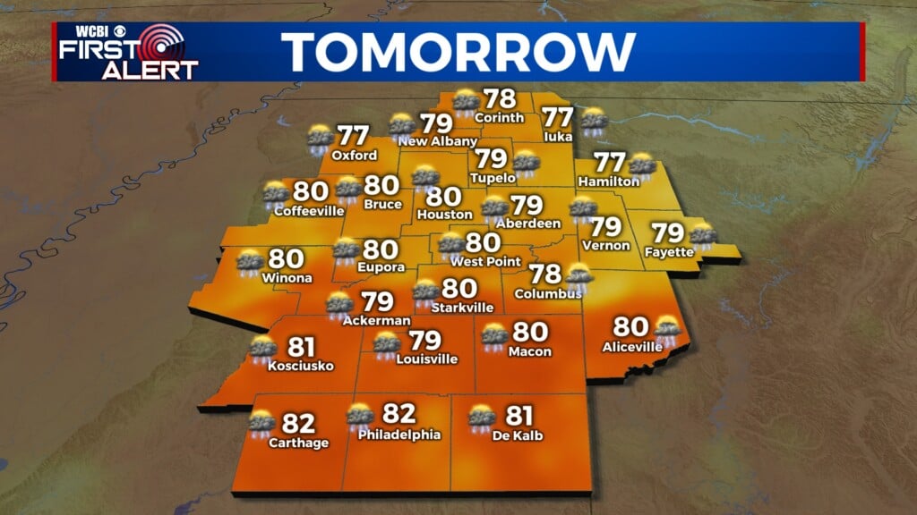
SUNDAY: Low 90s return for highs but there is still a 30% chance of showers and storms.
NEXT WEEK: Highs in the mid 90s are likely early in the week and that means the heat index will likely be well into the 100s during the peak heating hours. Daily rain and storm chances around 30% will remain so at least there is the chance of some natural relief from the heat. Lows stay in the 70s.


Leave a Reply