Severe weather chance Tuesday brings potential for prominent tornado threat
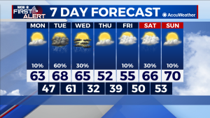
MONDAY: Highs get into the low 60s, amid some sunshine and a small chance for the rogue shower. Lows bottom out in the upper 40s overnight.
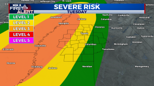
TUESDAY: Tuesday is where things get interesting. The latest model runs show the bulk of storms forming later in the evening and overnight. Atmospheric conditions favorable for the development of independent storm cells are present in model runs and the Storm Prediction Center (SPC) has already hinted at the possibility for a tornado outbreak in parts of the Mississippi Valley. Regardless of whether an outbreak occurs or not, damaging winds and a few strong tornadoes are possible with this event. We will continue to update you on the situation as it evolves.
REST OF THE WEEK: A cold front Wednesday will drop us back to cooler conditions and bring highs into the 50s and lows at or around freezing by Thursday. From there afternoon temperatures will slowly rebound into the 60s and eventually close to 70 by Sunday. Another chance for rain presents itself Saturday but this rain chance is not looking major to this point.


