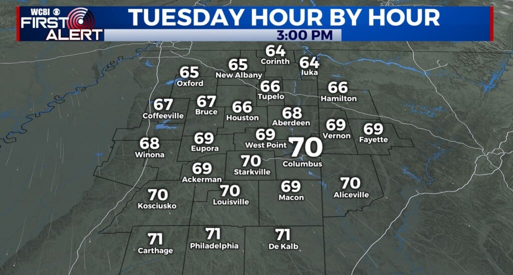
Relatively calm before weekend storm
COLUMBUS, Mississippi (WCBI) – End of the week will stay calm and for the most part dry. But moisture will build and conditions will become unsettled by the weekend.
THURSDAY NIGHT: With a regional High Pressure in place, conditions will maintain mostly clear and cool tonight. Lows could drop into the middle 20s to lower 30s. Bundle up Friday morning!
FRIDAY: Most of our Valentine’s Day will be filled with love, sun, and a few clouds filling in from the South. Temperatures will go from cold in the morning to tolerable in the afternoon, with highs in the 50s. There is a light chance for a few showers around dinner time, so be prepared with your rain gear.

SATURDAY: The day to watch! Any showers early in the day will lift northward, and at least some partial clearing is expected through the day. This will allow temperatures to soar into the 70s as strong south winds develop. This will bring warm, humid, and unstable air into the region for the afternoon and evening. While a rogue severe storm or two appears possible in the afternoon, it appears the greatest risk of severe weather will be from 6 PM until midnight. Damaging winds and tornadoes will be possible along a line of storms sweeping through ahead of a cold front. Make sure to be positioned to receive reliable watch/warning information!