Muggy, humid, storm chances
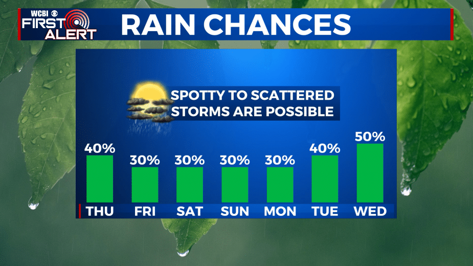
SUMMARY: The dead of summer is here and that means more heat and humidity for use to endure. Highs each day into next week will be in the mid 90s with heat indices as high as 110. Spotty storms will remain possible each day so hope for a short lived cool down if one can manage to find your location.
WEDNESDAY NIGHT: Turning partly cloudy. Muggy lows in the mid 70s. Light wind.
THURSDAY: Partly cloudy, hot, and humid. Highs in the mid 90s. Heat indices between 100-110. A 30-40% chance of spotty to scattered storms from late morning through early evening.
THURSDAY NIGHT: Turning partly cloudy, warm, and humid. Lows in the mid 70s.
FRIDAY: Partly cloudy, hot, and humid. Highs remain in the mid 90s with heat indices between 100 and 110. A 30% chance of pop-up storms during the heating of the day.
WEEKEND: Partly cloudy, hot, and humid. Daily rain and storm chances in the 20-30% range. Highs in the mid to upper 90s with heat indices between 100 and 110. Lows in the mid 70s.
EARLY NEXT WEEK: More heat, more humidity. Rain and storm coverage appears as if it will become higher by Tuesday and Wednesday. If that does take place daytime highs may only be around 90 by the middle of the week. Lows stay in the 70s.
Follow @WCBIWEATHER on Facebook, Twitter, Instagram, and the WCBI News App


Leave a Reply