Ida to bring significant impacts to the Lower MS valley Sunday – Tuesday
SUMMARY: All eyes are on Hurricane Ida as it continues moving toward the Louisiana coast. It’s set to strike the southeast LA coast as a category 4 storm Sunday afternoon. Conditions in northeast MS and west AL will deteriorate Monday and Tuesday.
SUNDAY: Mostly cloudy and slightly less hot with highs in the upper 80s. There’s a better chance of afternoon or early evening showers or storms as the outer edges of Ida’s moisture begin to move into the region.
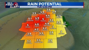
MONDAY/MONDAY NIGHT: Conditions will gradually deteriorate through the day as rain intensity increases. Expect several hours of steady to heavy rain by the afternoon and evening and into the overnight hours. 3-5″ of rain could fall, and a flash flood watch is in effect. Spiral bands around Ida will also be moving into the region, increasing the tornado potential as well. The highest tornado threat looks to develop Monday afternoon and could last well into the overnight hours.

TUESDAY: Heavy rain and an isolated tornado threat could linger through the morning hours, but conditions should improve by afternoon as the center of Ida starts to move away from the region.
REST OF WEEK: Much quieter weather should return to the Twin States with highs in the 80s.


