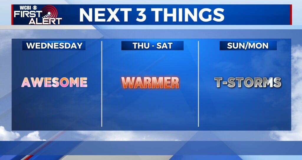
Heavy rain, flood potential continues Wednesday
COLUMBUS, Mississippi (WCBI) – Rounds of heavy rain and embedded storms continue through Wednesday night. After a brief break Thu/Fri, additional severe potential works in Saturday.
WEDNESDAY: Expect a near-washout type day with steady to heavy rain likely. Some embedded thunder will be possible through the day, but we don’t expect any severe weather issues during the daytime hours w/temps in the upper 50s and lower 60s.
WEDNESDAY NIGHT: Depending on how the late-afternoon unfolds, we could see some unstable air briefly surge up toward Noxubee/Kemper/Pickens counties between 5-9p. Should this occur, a brief window of severe potential would exist as the actual front passes through the region w/additional storms. Otherwise, expect one last push of downpours area-wide through the evening. Temperatures will eventually fall into the 40s and upper 30s after midnight.
THU/FRI: Expect a breezy day with highs likely struggling to reach 50 degrees despite some clearing by afternoon. A briefly COLD Friday morning is on the way with lows dropping into the 28-31 degree range. Sun & clouds Friday give way to overcast conditions Friday night as a few showers become possible.
SATURDAY: Scattered showers or storms could be ongoing early in the day, but this activity should lift northward out of the region by midday. Warm, humid, and unstable air will flow northward and set the stage for an elevated threat of severe weather after 3 PM. The best coverage of storms looks to settle in toward the evening hours, but this could change. Stay tuned for more fine-tuned forecast w/updates on particulars over the next few days.

SUNDAY: After Saturday night’s storms exit, we’ll see much colder air move in Sunday. The sky will only partially clear in the afternoon as highs stay in the 40s.