Front brings scattered storms Sunday and some relief for next week
COLUMBUS, Mississippi (WCBI) – Another HOT and humid end to our Saturday with mostly dry conditions through the rest of tonight. Hot and humid conditions continue into our Sunday with a cold front that passes through the afternoon to bring us a few scattered showers and thunderstorms. Some of these storms could be locally heavy and intense. After the storms on Sunday, we’ll see some relief from the heat with some cooler temperatures and less humid air moving in for the start of the next work week.
TONIGHT – Staying overall hot and humid to end off our Saturday night! Things have cleared out for the rest of tonight with calm and clear conditions, so a beautiful evening for any Saturday night plans! Temperatures will drop into the mid 70s tonight.

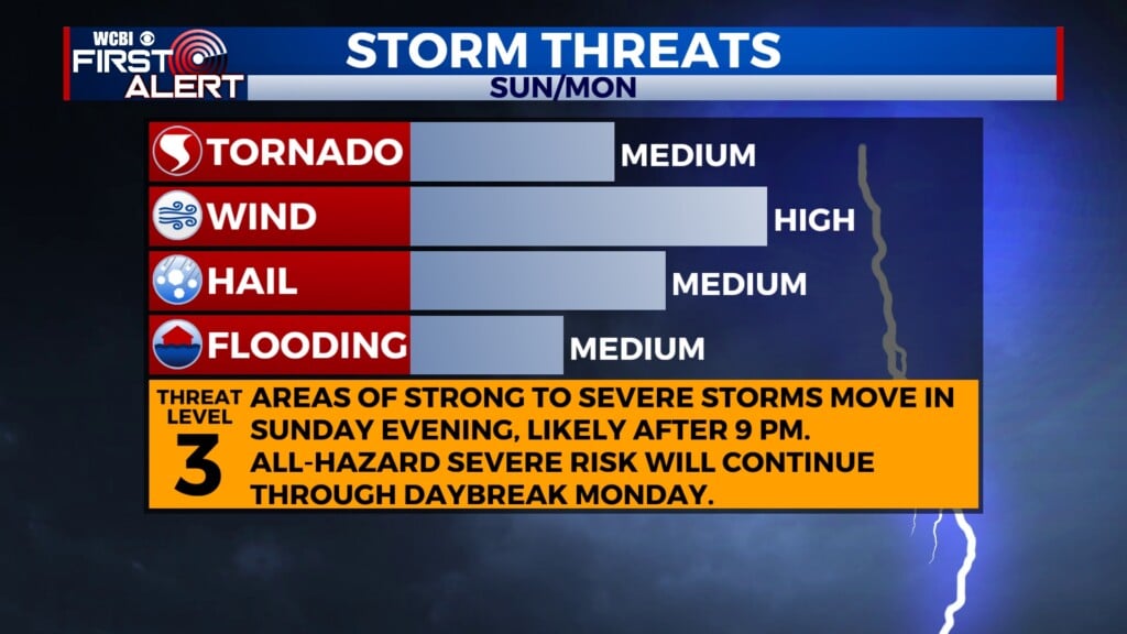
TOMORROW – Expect another HOT & HUMID day in store for our Sunday with highs in the upper 90s and heat index values of 110+. With extremely hot and humid conditions once again, we are placed under another Heat Advisory for tomorrow from 10 AM to 8 PM. A cold front looks to push through tomorrow afternoon to bring us a few scattered showers and thunderstorms across the area with the heaviest of the storms staying primarily south of the Golden Triangle. Some of these storms could be locally intense with heavy rainfall, gusty winds, and possibly some hail, so we are placed under a level 2 Slight risk for severe weather. Storms look to start developing in the early afternoon with a few more isolated storms later in the evening.

NEXT WEEK – After the cold front passes on Sunday we have much nicer weather on the way! Expect some cooler and less humid conditions to return with highs in the 80s and overnight lows into the lower 60s!