Few storms Thursday ahead of potential significant severe late Friday and Saturday
COLUMBUS, Mississippi (WCBI) – While a few storms will move through Thursday, chances of more significant severe weather will increase Friday into Saturday.
THURSDAY: A weakening disturbance will bring isolated to scattered showers and storms to the region Thursday, but things should be clearing up by afternoon. Highs should top out in the 73-78 degree range.
THURSDAY NIGHT: Passing clouds with lows in the upper 50s.
FRIDAY DAY: The day itself looks fairly pleasant, warm, and breezy with highs in the low 80s w/a mix of sun & clouds. Expect southerly winds to gust up to 20-30 mph a good portion of the day.
FRIDAY NIGHT: The atmosphere will be becoming increasingly favorable for severe storms, but questions remain on the potential coverage of storms. With lots of dry air and some capping, storms may struggle to develop. However, increased warm air advection into the night could be just enough to get one or two storms to fire closer to or after midnight. If any storm forms, the environment would support all severe hazards. This is a more “conditional” threat, meaning storms may not form at all…but if they do, we have to be ready. This potential will be highest between midnight-6 AM Friday night into Saturday AM.
SATURDAY: This could be a potentially significant weather day. Questions remain on exactly what happens during the morning, but an area of rain and storms may develop over central MS early and surge northward into Tennessee. In its wake, the environment will be primed for supercell storms to form around lunch and into the afternoon. Given the parameter space, these supercell storms would be capable of producing strong tornadoes and could be longer-lived as they track into Alabama. A line of storms is also possible late in the afternoon ahead of the Pacific front, capable of producing all severe hazards as well.

CALL TO ACTION: The best thing is to be prepared and to be updated. Review your action plan and be ready if watches and warnings are issued. If you live in a mobile home, you must have alternate, adequate shelter.
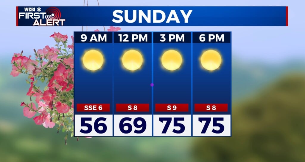
SUNDAY: Gradual clearing is in store w/highs reaching the upper 60s!