Sunny, warm Wednesday ahead of building storm potential late week
COLUMBUS, Mississippi (WCBI) – Another beautiful, sunny day is in store Wednesday before an active stretch of weather begins Thursday into the weekend.
WEDNESDAY: Expect another gorgeous, warm day w/plenty of sun and highs in the 76-81 degree range. Like yesterday, some degree of fire weather concern will develop in the afternoon as winds pick up to 15-20 mph and RH values drop. Burn bans continue for Itwamba, Alcorn, and Panola counties.

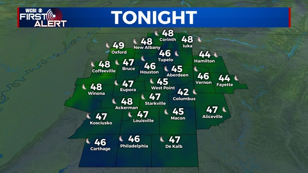
WEDNESDAY NIGHT: The evening hours stay dry as clouds steadily increase. Scattered showers and a few storms become possible after midnight, but they should be in a weakening state from the Arklatex.
THURSDAY: A few lingering showers and storms stay likely through the day, and one or two could briefly become strong to severe with gusty wind/hail. Most will remain sub-severe, and most should clear by afternoon.
FRI/SAT: High impact weather possible. Friday’s daytime will bring warm, windy, and variably cloudy weather with highs reaching the 70s to low 80s. Wind gusts up to 30 mph will be possible. Friday evening starts up severe potential across the region – while there may not be a lot of storms, a few could develop after 9 PM. We could also see a broken line of storms move in from Arkansas. The environment will be becoming increasingly favorable for all severe weather hazards into the overnight hours, so ANY storm will carry potential to grow intense quickly. Moving into Saturday, the environment shown by models continues to look quite favorable for intense, potentially significant severe weather to unfold during the day & afternoon. The storms should be exiting the coverage area sometime after sunset Saturday.