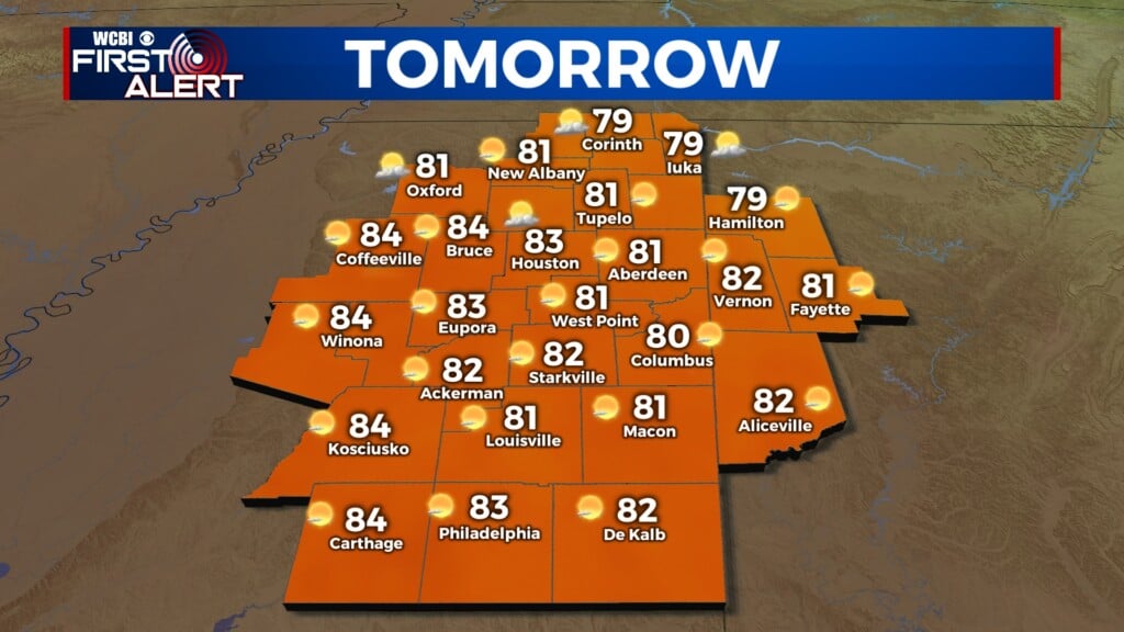
Unsettled rain pattern
COLUMBUS, Mississippi (WCBI) – Stayed dry for the beginning of our Valentine’s Week, but an unsettled pattern for rain will be moving in shortly.
MONDAY NIGHT: A few light sprinkles may be possible, especially across the northern third of the area. Otherwise, the rest of the corner will stay dry and with heavy clouds. Temperatures overnight are likely to drop into the middle 40s.

TUESDAY: Morning commute will likely be dry across NE MS, but rain showers and thunderstorms will begin developing across our NW counties soon after. Rain potential will continue throughout the rest of the morning and afternoon. The stalling cold front will trap moisture across the southern 2/3 of the area the rest of the evening. There is potential for 1-2″ of accumulation by the end of Tuesday.

WEDNESDAY: The warm air will initiate a warm front to push North across northern Mississippi. As this warmer, more unstable air will move ahead of the next cold front moving in from the West. If that unstable air is able to push in ahead, there is potential for strong to severe weather. The Storm Prediction Center has placed the central portion of the viewing area in a Level 1 – Marginal Risk, with our southern fringe counties in the Level 2. Despite this uncertainty, heavy rain is LIKELY. Another 2-3″ of accumulation is possible by the end of Wednesday.