Staying warm with storm threat Wednesday night
COLUMBUS, Mississippi (WCBI) – Above average temperatures continue ahead of Wednesday evening’s storm potential.
TUESDAY: Clouds increase as moisture returns to the Deep South. A few showers are likely to move into the area after lunch as well, keeping high temperatures in the mid to upper 60s.
TUESDAY NIGHT: Cloud coverage will continue along with the chance of patchy fog developing after midnight. Lows will only drop into the middle 50s.
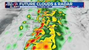
WEDNESDAY: Expect a variably cloudy, warm, and breezy day with highs in the lower 70s for most. While spotty/occasional downpours are possible through the day, the main “event” will hold off until after sunset. Showers and storms will develop into the region from the west/southwest, bringing potential severe weather. For now, the timeline for severe weather looks to be from roughly 6p to 2am. Damaging wind gusts and a tornado threat will accompany the storms, so make sure to have multiple ways to receive weather information!
THURSDAY: All storms should be out before sunrise, leaving a mix of sun and clouds for the remainder of the day. Highs will still reach the upper 60s ahead of the parent cold front. Come see us at Rent Auditorium on MUW’s Campus at 6 PM!
FRIDAY: A final round of scattered showers under a mostly cloudy sky will close the week out. Highs will still reach the upper 50s before falling quickly Friday night to below freezing.
WEEKEND: With high pressure nearby, expect plenty of sun each day with cold mornings and cool afternoons.
