Unseasonably warm week ahead
COLUMBUS, Mississippi (WCBI) – Along with above average temperatures, rain chances will remain as well.
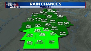
MONDAY: On and off rain is likely through the day, becoming more widespread with northward extent. Through the day, a warm front will slowly lift north across the state, steadily bringing warmer, more humid air to the region. Afternoon temperatures will range from the mid 50s to mid 60s.
TUE/WED: Rain chances become spotty as warmer, more humid air takes hold across the region. The aforementioned warm front will be well north of the region, taking the widespread rain chance with it. Still, isolated showers are possible each day with highs in the 70s.
THURSDAY: This is likely to be the warmest day of the week as highs approach the mid to upper 70s ahead of another front. Chances for rain will increase Thursday night ahead of the front.
FRIDAY: Slow clearing should occur behind Thursday night’s front. Temperatures will be knocked into the 60s for daytime highs.
WEEKEND: The unsettled pattern continues as a quick return of moisture is expected by Saturday afternoon. At least scattered showers are anticipated Saturday PM into early Sunday. Stay tuned for further updates!


