Multiple rounds of rain and storms this week, keeping an eye on Wednesday’s severe storm potential
COLUMBUS, Mississippi (WCBI) – Monday marks the start of an unsettled warm, wet weather pattern. Multiple rounds of rain and storms lie ahead this week. All eyes are on Wednesday’s potential for strong to severe storms.
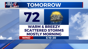
MONDAY: Scattered showers and thunderstorms will develop across the region, especially during the morning time. While rain may be heavy at times, severe storms are not expected. Some may hear a rumble of thunder. High near 72 degrees. Winds: south at 10-20 mph, gusts may be higher. Chance of rain: 60%.
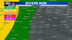
TUESDAY: An isolated shower is possible across the region, but overall rain coverage will be less than Monday. Our western communities have the best shot at seeing an isolated shower or thunderstorm. If storms can develop and strengthen, a damaging wind gust is possible along I-55. Otherwise, expect a mix of sun and clouds. High near 80 degrees. Winds: south at 10 -15 mph, gusts may be higher. Chance of rain: 30%.
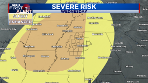
WEDNESDAY: Just remember – this is the day to watch. Wednesday has the potential to be an active severe weather day, with strong to severe storms looking likely for much of Northeast Mississippi and West Alabama. We should have a better idea on timing and specific threat levels sometime tomorrow, but for now, you’ll need to be weather-aware all of Wednesday and Wednesday night. All severe weather hazards are possible – tornadoes, damaging winds, large hail, and heavy rain. Parameters for thunderstorm fuel and hail are more impressive compared to the previous severe weather events this year. However, wind energy doesn’t look as impressive. Regardless, the environment will be plenty favorable for organized strong to severe thunderstorms. The entire region is under a level 3 out of 5 “enhanced” risk for severe weather. We’re watching this very closely and will give you all of the information you need. Stay tuned and check back for updates!


